The Nullarbor Plain by Dave Gillieson & Andy Spate
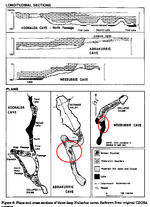
This is Australia's largest karst (200,000km2) and perhaps the most intensively studied. The region has an arid to semi-arid climate with annual rainfall between 150 and 250mm, with a winter maximum. Annual evaporation is 1250-2500mm (McKenzie et al., 1987). Relief is low, less than 5m, with slope angles of 1o-3o. The Nullarbor Plain has no surface drainage, but relict stream channels are found on the northern and western flanks of the plain. These have meandering traces and are infilled with alluvium and aeolian deposits. Elsewhere there are aligned depressions with claypans; these are of structural origin (Lowry & Jennings, 1974). These claypans, locally termed "dongas" act to channel the slight runoff and direct it into dolines and blowholes. Dolines are sparse, steep sided and show evidence of collapse into underlying cavities (Photo 3). Blowholes are very numerous, fed by deep solution pipes of complex origin. The caves are extensive, much modified by salt wedging and collapse processes, and commonly descend gently to near-static pools and lakes of brackish to saline water. A low gradient watertable underlies the plain and its depth ranges from 30m in the north to 120m in the south. The flooded tunnels of Cocklebiddy Cave are in excess of four kilometres long - most of it only explorable by scuba diving. Withdrawal of hydrostatic support at times of lower sea level has led to collapse into these watertable caves, allowing entry into large caverns such as Koonalda, Abrakurrie, and Weebubbie Caves (Figure 1).
A particular feature of the Nullarbor caves is the abundance of halite which produces both speleothems and many weathering forms through wedging during recrystallisation. Gypsum speleothems are also abundant with calcite speleothems less obvious largely because of destruction through salt wedging. Speleothem history has much to contribute to the study of past climates and the history of the caves. Lowry and Jennings (1974) provide a good introduction to the geomorphology while more recent detail is given in the review by Gillieson and Spate (1992).
When the long-term operation of karst processes in the arid zone is considered, a fundamental dilemma emerges: are the present features the product of slow, low intensity processes in a variable but essentially arid climate, or do they reflect inheritance from a past, more mesic climate under which processes operated at a faster rate? There is some evidence for wetter conditions on the Nullarbor Plain in the distant past. Firstly, the speleothem sequences mentioned previously. Second, the dark brown to black colours of calcite speleothems which have been demonstrated (Caldwell et al., 1983) to be due to organic compounds such as humic acids, fulvic acids and phenolics, suggesting more effective leaching of soil organic matter. Third, the presence of relict solution tubes and spongework in Thampanna and Old Homestead caves, and the presence of solution scallops in the flooded tunnels of Weebubbie and Cocklebiddy caves (Grodzicki, 1985) suggests a more vigorous fluvial regime in the geological past. Thus the cave systems of the Nullarbor may have originated in a more humid climate phase, and probably span the entire Quaternary. Since the onset of the present arid climate, these features have been heavily modifed by salt wedging and collapse processes (Lowry & Jennings, 1974).
Today exposed outcrops are merely pitted by raindrops, and no solution rills are present. Some solution of limestone does occur in the coastal fringe of the Nullarbor Plain and mixing corrosion may be important in this context (James et al., 1990). The large caves of the Nullarbor may have been initially formed by enhanced solution at the mixing zone of fresh and saline waters (Table 2). The groundwater of the Eucla Basin has a high salinity (Lau et al., 1987; Table 3) and some solution may also be occurring at great depth in the limestone. Inland periodic low-intensity rainfall may cause some solution on the margins of clay pans, and calcretes are forming, but overall rates of solution must be very low. Of more significance are the intrusions of rain depressions of tropical origin which occur twice or thrice per decade. These have the capacity to dump large amounts of water on the western Nullarbor, flooding claypans and dolines, and perhaps maintaining epiphreatic passage forms in several caves such as Thampanna and Old Homestead.
| Site | Ca++ | Mg++ | Na+ | K+ | HCO3- | SO4-- | Cl- | pH |
| Seawater Standard | 400 | 1272 | 10560 | 380 | 285 | 2650 | 18980 | 8.50 |
| White Lake, Mullamullang Cave, Nullarbor |
317 | 319 | 2200 | 26 | 57 | 677 | 4365 | - |
| Lake Cigalere, Mullamullang Cave, Nullarbor |
326 | 300 | 4165 | - | 33 | 855 | 4580 | - |
| Nurina Cave, Nullarbor |
891 | 1052 | 10440 | 127 | 267 | 3630 | 17950 | 7.48 |
| Tantabiddi well, Cape Range |
113 | 141 | 999 | 36 | 336 | 240 | 1810 | - |
| Milyering well, Cape Range |
126 | 188 | 1414 | 53 | 316 | 358 | 2550 | - |
| Pillara spring, Kimberley |
125 | <0.1 | 3.1 | <0.5 | 318.4 | 4.5 | 3.9 | - |
| Baralumla spring, Kimberley |
83.2 | 1.8 | 4.3 | 0.8 | 198.7 | <3.0 | 10.8 | - |
| Windjana bore, Kimberley |
113 | 0.5 | 10.9 | <0.5 | 272.6 | 6.3 | 11.4 | - |
| Type | Salinity | % of potential yield |
| Fresh | <500 mg L-1 TDS | 9% |
| Marginal | 500-1500 mg L-1 TDS | 56% |
| Brackish | 1500-15000 mg L-1 TDS | 31% |
| Saline | >15000 mg L-1 TDS | 4% |
During the last interglacial - glacial cycle the sea level dropped at least twice, steepening hydraulic gradients. This prompted a shift in the isohyets, as reflected in pollen stratigraphy (Martin, 1973). Thus during the last glacial maximum the arid chenopod shrubland of the interior plain extended across terrain which today lies closer to the coast and supports eucalypt woodland. Conversely, during the last interglacial eucalypt woodland would have extended further inland than it does today, and this may have enhanced solutional processes. These changes in the vegetation cover may have acted to destabilise the continental dunefields to the north of the Nullarbor, and allowed reddened quartz sands to accumulate downwind in caves and dolines on the eastern portion of the plain ( Spate et al., 1984). Cave and doline infills on the eastern margin of the Nullarbor are dominantly red aeolian quartz sand with well developed wustenquarz. At least three different pedogenic cycles are involved, with some loessic additions ( Spate et al., 1984). These sands have their origin in the Great Victoria Desert, and suggest a wind regime different to the predominantly southerly to southwesterly airflow today. The distribution of these sands, in a narrow belt around the Diprose Caves, suggests that they may have moved as sand streaks across the gravelly plain. The most recent disturbance of these sands, dated by thermoluminescence at <360 years B.P., may reflect the increased fire frequency consequent on pastoralism and the spread of rabbits across the Nullarbor Plain. Recent environmental impacts on the Nullarbor and other arid karsts are reviewed by Gillieson (1993).
Contact:- David Gillieson, Senior Lecturer, Dept. of Geography & Oceanography, University College, University of New South Wales, Canberra, ACT 2601, Australia. Phone 61 6 2688305 Fax 61 6 2688313 email: